In this Blog Post:
It was on February 8, 2005 that Google launched their web mapping service aptly named Google Maps. On February 8, Google Maps will turn 15, through the years Google maps has changed it logos and improved its features thus bringing it to where it is now, a very useful and indispensable app for everyone.
For those using Google maps since its launch, that includes us here in team techtography, would know the very thing that made this app so successful. It could be a lot of things but one thing really stood out for Google maps amidst other web mapping service apps out there and that is accuracy. Google maps is so accurate around 90% of the time that people have made this app one of the must haves in their mobile phones.
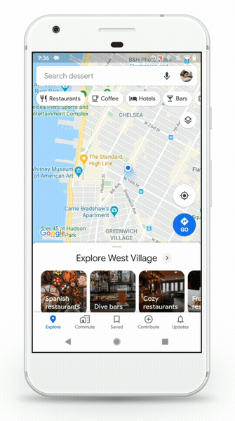
(adsbygoogle = window.adsbygoogle || []).push({});On it’s 15th year Google Maps will be introducing new features in the platform. For Android and IOS users, they will soon see five tabs on the app for easy access on the features that are considered to be useful for the users. These tabs are the following:
The New 5 Tabs of Google Maps
- Explore – a tab that helps you find nearby places. Restaurants, Bars and other business establishments which also shows their reviews and ratings.
- Commute – this tab helps you find the most efficient route for your commute. Travel times, route suggestions and real time traffic updates are all in this tab.
- Saved – All your saved places in one convenient spot. This tab allows you to easily access your saved places.
- Contribute – add missing places, rate or review an establishment or add photos and videos to earn those points as a Local Guide.
- Updates – must see and trending spots that were contributed by local experts and publishers will be placed on this tab. Not only that, you can also directly chat with business owners to get questions answered.
The New Google Maps Logo
Through the years the Google Maps logo has gone through a lot of makeover, on its 15th year Google will once again update the Google Maps logo. This time, “the pin” is the highlight of the logo, actually it is the logo. The colors of course are that of the Google color, festive and fun! But don’t just rely on our description watch the video below:
Better Data on Crowdedness Prediction
For some parts of the globe, the crowdedness prediction was introduced last year. The crowdedness predictions is a feature on Google maps that will help users see how crowded a train, subway or bus is going to be based on data on past rides. Google maps will update this feature to help more people learn more about important details regarding their bus, subway or train commute. The following features will be added (however some features are not applicable in other countries, hence it might only be rolled out in countries where they are applicable).
- Temperature – Get information on the temperature to help you determine which time of the day would be the best time for your commute or at least warn you ahead of time should you proceed anyway, this will allow you then to prepare for such extreme temperature.
- Accessibility – accessibility is always in the heart of Google Maps, this time, it is getting a more defined role. People can find public transports with accessible entrance, seating, staffed assistance for those who have special needs.
- Women’s Section – there are countries that has designated women’s section, easily finding these in your public transport saves a lot of time, this is why Google Maps has added this feature.
- Security On-board – know if the public transport has security on-board, this will help you to choose which public transport to take.
- Number of Carriages available – this feature is useful in Japan where you can choose a public transport with a specific number of carriages allowing you to have a higher chance of getting a seat.
These features will be rolled out sometime March and will definitely help commuters during their daily commute. Google maps will also give you the opportunity to help other riders by answering a short survey, where data gathered would be used to further optimize commute for the users.
(adsbygoogle = window.adsbygoogle || []).push({});Enhancing Live View
Live view was also rolled out last year and for us at techtography, this is one of the coolest feature of Google maps aside from the other cool features of course. Live view is a combination of smartphone sensors, real-world imagery and machine learning. These combinations would show your current surroundings overlaid with AR or Augmented reality. Google maps plans to expand the use of Live view as well as test new capabilities for this feature.
In Conclusion
Those 15 years of Google Maps really made this app grow into something that people really love. Amidst all their ups and downs, hits and misfires, Google maps has grown to be an app the does not only provide accurate information, it also became an app where users can truly say that they have contributed to the growth and accuracy of Google maps, one could say they helped nurture the app in one if not all of its phases. Happy 15th Google Maps! We will see you out there on the journey to the next years to come.
For more information, see our complete guide on How to Use Zoom, a Comprehensive Guide for Starters.